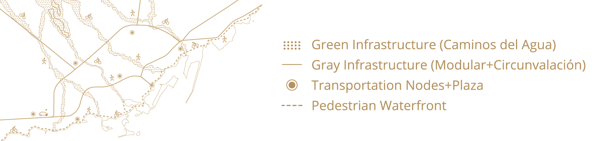
Calvia Coastal & Tourist Development

The municipality of Calvia is situated on the southwest end of the island of Mallorca.

It has nearly 60 kilometres of coastline and it concentrates more than 50,000 tourist beds and as many second homes which totals for more than 50% of the tourist accommodation on the Island. The proposal is based on the geographic system of “cavities” and “convexities” that characterizes Calvia’s coast. The design strategy aims to recover and update the development pattern of the irst tourist settlements where the “cavities” of the coast hosted tourist enclaves while the “convexities” were maintained as landscape reservoirs. This pattern is the basis of the vivid image that characterizes the Majorcan coast, and an example of intelligent and sustainable development of the waterfront. The project also includes a model of sustainable mobility and eight tourist enclaves, each with its own unique identity and tourist proile.

Digital Totem®

The design upgrades the traditional advertising poles proliferating in malls and gas stations that are mainly used for advertising and business visibility.

The design strategy seeks to enhance its functionality by improving its visual access. The design system consists of rotating eight blocks of a prism in accordance with the movement of vehicles around the roundabouts where they are placed.

Each module includes a video screen similar to those in football stadiums and the video panels give information regarding access to car parks, availability of parking spaces and commercial ads.

Cenobio Pedestrian Access

The Cenobio of Valeron is a pre-Hispanic granary excavated more than five hundred years ago by the ancient inhabitants of the island of Gran Canaria.

Its difficult accessibility helped to preserve this large pantry from potential raids of plunder and looting. The project aims to connect the 300 meter gap between the car park and the archaeological site along a very sharp slope. The program of uses consists of an accessible pedestrian route, complemented by a control area and an interpretation center at both extremes. The project is resolved by three sections of control coming out from the evaluation of minimum land excavation and three diferent landscape experiences (cultural, panoramic and archaeological). The interchange area is the result of bridging the gap between the three control sections with 3D software.

The different spatial scenarios that the visitor enjoys along the way transform the visits of tourists into a memorable and educational experience.

Cicer Plaza

The code “Urban Beach” with which this project is launched, not only codiies but also explains the project’s strategy. The proposed public plaza combines the lexibility of beach spaces along with the comfort levels of urban plazas.

The design consists of an undulating topography that connects the beach with the surrounding streets, located at an upper level. The resulting space integrates pedestrian, urban and beach spaces in a coherent manner. Two indoor boulevards run underground and provide access to other amenities such as a wellness center, beach facilities and a sailing school. The claim “Under the pavers, the beach” perfectly expresses the aspirations of freedom and fun of an entire generation. Our proposal aims to rescue the informality of that beach without sacriicing the comfort of the pavers.

Las Palmas de Gran Canaria Waterfront

The project addresses nearly 40 kilometres of coastline, including east and west sides of the city. It also includes a sustainable mobility system as an alternative to the existing one. The solution incorporates two systems: one functional (heavy traic) and another more oriented to leisure-wise enjoyment (light and public traic). Functional mobility incorporates the existing by-pass and the major existing roads of the city. Leisure-wise mobility favours light and alternative traic, including bicycles, trams and pedestrians.

Ten well-equipped parks are placed along the waterfront, as a result of the crossing of urban and natural corridors. Each park seamlessly combines urban programs and facilities, transport hubs and open spaces. By exploiting the urban possibilities of outdoor living and mass enjoyment of the coast, the project aims to condense and deploy the subtropical potential of Las Palmas de Gran Canaria.

Gadeokdo Tourist Island

The Gadeokdo Island is entirely devoted to leisure and outdoor activities, and will become a globally renowned environmentally-sensitive resort city.

The proposed tourist developments are concentrated in three sites, where they share locations with traditional ishing villas that become “development anchors”. The proposed solution emphasizes a transversal occupation of the coast, leaving large empty areas of waterfront as landscape attractions and environmental reservoirs. A set of inland leisure facilities work as alternative attractions to the coastal amenities.

Most of the proposed urban fabric is placed on natural slopes leaving lat land for leisure and agricultural purposes. Buildings and landscape schemes are part of the water management system, working as stormwater channels and collectors. The energy strategy includes also geothermal, wind, solar and hydroelectric sources and it allows a selfsuicient provision of water for 30,000 tourists.